


On July 30, Governor Mike DeWine released a new Ohio Public Health Advisory System map.
“The good news is that more people are wearing masks in our urban counties and we are seeing the spread slow because of that,” said Gov. DeWine. “The bad news is that Ohio’s more rural counties are turning orange with significantly more spread taking place. I will again urge those who live in rural counties to wear masks while in public.”
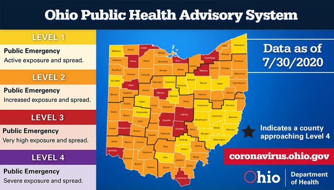 Remaining at Level 3:
- Allen
- Cuyahoga
- Erie
- Fairfield
- Franklin
- Hamilton
- Licking
- Lucas
- Henry
- Lawrence
- Marion
- Medina
- Montgomery
- Clark
- Defiance
- Hardin
- Athens
- Clermont
- Delaware
- Pickaway
- Scioto
- Union
- Richland
There are no counties on Ohio’s Watch List.
Detailed data on all 88 counties are now available on the Ohio Public Health Advisory System’s website. The system was developed to provide local health departments, community leaders, and the public with data and information on the severity of the COVID-19 spread in the counties in which they live. The system consists of four levels with specific risk-level guidelines. Each level is calculated with data gathered on seven public health indicators.